 |
||||||||
PHYSICAL FEATURES AND GEOLOGICAL SURVEY. SURFACE GEOLOGY -- COAL MEASURES -- BEDS ABOVE THE MULBERRY COAL -- ECONOMICAL GEOLOGY -- LOWER COAL BEDS -- THE MULBERRY COAL -- BUILDING ROCK -- IRON ORE -- MINERAL WATERS -- FIRE CLAY -- AGRICULTURE -- TIMBER SUPPLY. (Prepared by Professor G. C. Broadhead.) The area of this county is 873 square miles. Its surface is formed of agreeably undulating plains, terminating in the west part in a north and south range of mounds with other mounds in different parts of the county. These mounds, in the western part, are generally from 80 to 100 feet high. Six miles northeast of Butler, there are several of 80 to 100 feet in height. From these, for six miles northwest, our route would pass low mounds in a continuous range extending six miles further. We then reach a broad valley, 100 feet lower than the mounds and over six miles wide. Crossing the Miami Fork, we are again in the region of the mounds, and these continue to the south line of the county, only occasionally interrupted for a few miles by the streams and valleys. South of the Marais des Cygnes, the county is for the most part hilly and rolling, occasionally broken by wide valleys along the streams. In range 31, along the south county line, is a range of mounds extending east and west, passing southwestwardly and uniting with the high land in Vernon. Townships 41 and 42, range 29, are somewhat broken, the streams being separated by ridges often 200 feet high, rising by long slopes from the valleys. Passing southward over a rolling country to the waters of Panther Creek, we find a high, semi-circular ridge curving around the head of this creek, 240 feet in hight, and extending from Hudson southwest to Pleasant Gap and southeast for several miles. Within this high ridge or rim is the beautiful, undulating valley between Camp and Panther Creeks, elevated thirty to forty feet above the stream. From there the country slopes off into a beautiful plain towards Prairie City and Papinsville. A line passing northwest from the northeast part of township 39, range 29, to the northwest part of the county will touch along the principal dividing ridge and probably the highest ground in the county. It will also divide the waters of Grand River on the north from those of the Osage on the south. The principal tributaries of Grand River are Deep Water, Cove Creek, Peter Creek, Elk Fork, Mingo, the Deer Creeks and Mormon Fork. These generally start from broken depressions in the prairie, and pursue their course with increasing width of valley. Some of the valleys are sometimes a quarter to one-half mile and more in width, blending into a little more elevated plain. Grand River Bottoms are wide, with occasional ponds and marshes. The chief tributaries of the Osage, making southward from the ridge above named, are Mulberry Creek, Miami Fork and Panther and Camp Creeks, with other lesser streams -- as Shaw Branch, Willow Creek, Double Branches, Mound Branch, and Bone Creek and Knob Creek, forks of the Miami. The banks of the Osage are generally about twenty-five feet high. Its channel being often full, it is rare that it can be forded, even at very few places. With some necessary improvements in the channel, it could easily be made navigable for light draft boats every year up to Papinsville. This place is 240 miles by boat from the mouth of the Osage, and light draft steamers have occasionally been up to this point. The bottoms of the Osage are generally two to three miles wide, but are often quite flat and marshy. Other streams have reasonably wide bottoms. South of the Osage, we also find the streams originating from breaks in the high lands, thence passing off through widening flats to the Osage. These include Walnut Creek and its fork, Gillen's Creek, Burnett's, Cottonwood and Muddy Creeks. That this county has been at some former time subject to extreme denudation, is evident from the isolated mounds often seen. Their summits are probably of the same elevation as the higher ridges in the eastern part of the county. There has been a scouring from north to south, leaving isolated mounds protected from destruction by cappings of limestone. In the eastern part of the county the limestones on the summits are the same which maybe found beneath the base of the western mounds. The force of the glacial action which has caused this has been such as to bear away all drift pebbles from the surface excepting, when on the higher grounds. On the mounds east of Pleasant Gap, are often seen quantities of rounded gravel, mostly siliceous. The banks of Camp Creek have exposed at one place a bed of similar gravel with, sand. Among these latter pebbles one was obtained of quartzitic conglomerate. At Burnett's ferry the banks of the Osage show:
These gravel beds are occasionally met with at other places along the Osage. Wells dug at Papinsville show it to be thirty-five feet thick, of which thirty-one feet was yellow clay resting on four inches of blue clay and gravel. Beneath this was found a thin sandy stratum enclosing a tooth of an extinct species of horse. Still beneath was a gravel bed of five feet thickness, the pebbles mostly rounded and some adhering together. The pebbles are mostly siliceous, associated with fragments of coal and iron ore. From similar beds in the banks of the Marais des Cygnes, bones and tusks of mastodon have been obtained. Bates County is underlaid throughout by the coal measures. Including upper, middle and lower measures, there are in all about 500 feet of vertical thickness. The lower measures, including the Marais des Cygnes coal, crop out in township 38 and part of township 39, ranges 29, 30 and 31, and the eastern part of range 32. The lowest rocks to be seen in the county are on and near Panther Creek. At the ford west of Rockville we find:
These ores may in the future prove valuable. The lowest coal measure rocks in the county were penetrated in Mr. Seclinger's well in the east half of the northwest quarter of section 15, township 38, range 30. The well is 105 feet deep, and all sandstone (the upper sixteen feet shaly) except the lower tour feet of slate. This sandstone is seen in the Osage River at Papinsville. Near the head of Panther Creek we find a gray limestone supposed to be the equivalent of the lowest at Butler, 220 feet above the valley of Camp Creek. This limestone seems to crown the neighboring hills at many places. Below it there seems to be sandy shales nearly to the valley. Near the head of the eastern fork of Panther the thick coal is found. Judging from the topography of the surrounding country, this coal must be about 220 feet below the gray limestone just above named. In the south part of section 28, township 39, range 29, is a remarkable exposure of nineteen feet of dark bituminous shale, mostly slaty, and enclosing large dark bituminous limestone concretions in the lower part. It is very probable that this may be only a few feet above one of our thick coal seams. The following section taken two miles north of Pleasant Gap, shows the highest formations in this vicinity:
This group of rocks probably includes the equivalent of the Fort Scott Group, but is almost barren of coal. The limestones Nos. 2 and 4 of the above section are found at the head of all the streams north of this as far as the head-waters of Cove and Peters' Creeks. They also crown the hills within twenty to forty feet of their tops between Pleasant Gap and Butler, and we suppose them to be the equivalents of Nos. 50 and 55 of the general section of the southwest coal. Sandstone No. 56 of our southwest coal section is the highest rock seen just above the limestones last spoken of. It is generally a coarse deep brown sandstone, sometimes affording a good building material, but broken masses from it are often found in a pulverulent condition, which mingling with the soil gives it a deep brown appearance. The iron set free also very much assists in promoting fertility. This is found on all the higher ridges of range 29 and township 39, range 30 and occasionally on the north. Obscure remains of plants, with an occasional fragment of Stigmaria ficoides are sometimes found. Near Johnstown are seen rocks whose position can be but little above the thick coal of Panther Creek. At Shelton's, on Rockbottom Branch, are seen:
This section may be considered an exhibit of what we may find at many places on Deep Water for three or four miles northwest; also in the valley of Cove and Peter Creeks. At Mrs. Hackler's the coal has been mined in the bed of the creek, and on the hill over a hundred feet above is seen the brown limestone named above as occurring at the head of Panther Creek. The following section shows a partial connection of the Butler rocks with the upper coal measures: Section by C. J. Norwood, from the top of the mound, in the northwest quarter of section 28, township 41, range 30, southwest to a branch of Mound Creek. No. 1 -- 15 feet slope from the top of the mound.
Butler section:
The upper part of this section to No. 7 is seen at Butler; also Nos. 14 to 17. The intermediate beds are concealed at Butler, but exhibited at Braggin's, one mile northeast. The beds seen next below this Butler Section are thick exposures of soft sandstone, which, eastward on Mound Branch, and four miles south, between Possum Creek and the next Branch south, thicken up to eighty feet. The upper beds of the Butler Section are just below the Mulberry Coal; in fact, I am inclined to think this coal may yet be found in the highest hills at Butler. These are well developed on Miami Fork and Mulberry Creek. Their relation to the coal can be obtained from our south-west coal section. The beds from No. 67 to 72 and 73 are here generally found, and are well exposed at some of the coal banks. Nos. 57 and 67 are connected by their intermediate beds.at James H. Becket's, in north-east quarter south-east quarter of section 10, township 40, range 32. The limestones near Nos. 67 and above, appear at many places on Mulberry Creek, on the south side of Marais des Cygnes. These rocks appear nearly everywhere on the waters of Walnut Creek, and are also found at the head of Duncan's Creek. Near New Home, and on the waters of Burnett's Creek, Prior's and and Reed's Creek, are beds which may be referred to the Fort Scott Coal. But the Fort Scott coal itself was not certainly recognized. On the above-named stream, further south in Vernon, are thin seams of coal, which can certainly be referred to the Fort Scott Group. The evidence is that the coal thins out north and north-east. In section 11, township 40, range 33, is a mound ninety-five feet above the general surface of the prairie. Its cap rock is a limestone, apparently belonging to No. 74 of the General Section of the Upper Coal Measures of 1872. It abounds in Lophophyllum and also contains Productus Nebrascensis. On the prairie, 102 feet below, we find a limestone which is probably No. 75 of the southwest coal section. The mounds in sections 27 and 28 of the next township north, eighty to one hundred feet high, are also capped with limestone of Upper Coal Measures. The farthest limit south where we have recognized any Upper Coal Measures is on the top of a low mound in section 5, township 38, range 33. On the mounds, six miles northeast of Butler, are also found Upper Coal Measure Limestones. The latter mounds are 120 to 140 feet high. Farther west and northwest the mounds develop into continuous ridges, for example at West Point and at Parkersville and northwest. They are all capped with Upper Coal Measure Limestones, including No. 72 to No. 80 of our General section of the Upper Coal Measures, 1872. No. 72 contains some well preserved and fine specimens of fossils, including, near Holderman's Orthoceras (large species) Nautillus, (two or three species, probably four) Cyrtoceras, Pleurotomaria coxams, like P. turbiniformis, Schizodus Wheeleri and Pinna peracuta. In section 11, township 44, range 33, Productus Nebrascensis and Lophophyllum proliferum. The Lower Coal Series in townships 38 and 39 of ranges 29 and 30, may include two or three seams. The lowest workable bed of eighteen inches to two and one-half feet has been worked on E. Shaver's land, near Willow Branch, three miles northeast of Papinsville; at Hamilton's, one mile northeast of Prairie City and one and one-half miles north) near Shaw Branch; at J. M. Williams', on Camp Creek and on Panther Creek. The entire thickness of the bed at Williams' was not seen, only one and a half feet being exposed. Mr. Williams says it is three and four feet thick. If so it is the equivalent of Yates' Coal on the head of Panther Creek. From its topographical position I was inclined to refer it to a bed occupying a little lower horizon. A black, bituminous limestone, with Pr. muricatus and a calcareous conglomerate, containing Orthoceras Rushensis occur just above it. This shows that the coal here and that at Shavers may be the same, for a similar limestone is also found at the latter place, containing besides the above named fossils, Productus Prattenianus, P. Nebrascensis, P. semireticulatus, Hemphron- ites crassus and a small Lingula and Discina. At Shaver's, the coal is twenty-two to twenty-six inches thick. Section on Hamilton's land in southeast quarter of section 7, township 38, range 29:
Hallam's coal, examined by C. J. Norwood, in the northeast quarter of section 1 1, township 38, range 30, is one and one-half to two feet thick. This coal underlies at least five sections in the northeast part of township 39, range 29, and dips beneath the surface of the townships west and north. Section at Mrs. Annie Holt's, southwest section 14, township 39, range 29. (By J. C. Norwood.)
This section closely resembles the section taken at the foot of Timbered Mound, on the Marmaton, in Vernon County. I regard the coals as identical. D. Wall's coal is the same as Mrs. Holt's. It is found in a branch in the southeast quarter of the northwest quarter of section 23, township 39, range 29, and is 3 1/2 feet thick. A bed of concretionary limestone, abounding in Productus muricatus and containing Entolium-aciculatum, Hemipronites Productus Nebrascensis, Naticopsis and Chonetes mesoloba, occurs immediately above. (Note: In these fossils we have analogy to the coal of Colonel Williamson, near Windsor, Henry County. We suppose it to be the same coal.) This is overlaid by bituminous shale. The coal also crops out two and a half feet thick at Dr. Taussy's, in the northeast quarter of the southeast quarter of section 15; M. Daily's, southwest quarter of the northwest quarter of section 23; T. James, southwest quarter of the southwest quarter of section 13, and John's, in the southeast quarter of the northeast quarter of section 14, all in township 39, range 29. In township 38, range 29, it is also found on McDouglas' land, in the northwest quarter of the southeast quarter of section 11, and Mr. Campbell's, in the southwest quarter of the southeast quarter of section 2. At Joseph Wilson's, in the northwest quarter of the southwest quarter of section 14, township 39, range 29, the coal is three and and a half feet thick. Near the head of Panther Creek, coal three to four feet thick is worked on the land of Gilbreath and of Yates, in lot 1, in the northeast quarter of section 4, township 39, range 29. A section of Yates' discloses:
Although thicker, the associated beds would indicate this to be the same coal as that at Williams' and Shaver's. Further north and west this coal has not been seen, but certainly could be reached by shafts sunk to the proper depth. On low ground near Mormon Fork, in section 35, township 42, range 32, I was informed that parties boring for oil reported about the following section:
At 175 feet from the surface, two feet of coal was reported, and six feet of coal at 225 feet. The well was bored 525 feet, passing chiefly through sandstone and soapstone. There seemed to be a marked discrepancy in the statements of different persons as to the depth of the coal. Mr. Holderman's account gives two seams at 300 to 320 feet, the upper 3 feet, the lower 9 feet, with a 3 feet bed at 80 to lOO feet. The latter is probably the Mulberry Coal; the others are lower coals -- Nos. 18 and 23 of our southwest coal section, and the same that are found at Yates'. In these two statements of the boring, although the reports show a discrepancy of from 80 to 100 feet, I still feel confident of the fact of the coal existing at a depth of not over 350 feet from the surface. On Panther Creek, a short distance below Yates', on the land of John Atkinson, another thin seam crops out above the coal of Yates'.
The section here is:
The upper coal -- No. 4 of this section -- bears a close resemblance in its associated strata to the lower coal of Timbered Hill. If it is, we have three workable coals within a short vertical distance of each other. At Ewell's and Parker's are two seams near together, which seem to lie above the lower Timbered Hill coal. Lower coal south of the Marias des Cygnes: On John Schrum's, in west half of southwest quarter of section 30, township 38, range 31, is a one-foot seam, with two feet of ochreous clay beneath. A good seam of eighteen inches is reported to be two and a half feet below this coal, but was not exposed. Hanley has the same coal in northeast quarter of section 20, township 38, range 31. In southeast quarter of southeast quarter of section 31, township 39, range 31, on C. W. Bridgewater's land, we have:
At H. Bridgman's, in southwest quarter of the same section, is the same coal, but thicker. At the latter place it is three and a half feet thick, capped by five inches of ochreous shales, separating it from the bituminous fossil bed. Section at Benham's coal bank, northeast quarter of southeast quarter of section 36, township 39, range 32:
On Mr. Carr's land in southwest quarter of section 33, township 39, range 31, is the same coal as that of Bridgman's. The section here is:
Aerhardt, near by, has the same coal, but it is covered by three to five feet of hard, calcareous shale at the top passing into blue limestone, with a thick buff crest. Most of the coal is covered by water. Three feet was seen at the opening of the drift by which it is worked. On the land of Miss Nancy Morse in section 35, township 39, range 32, I observed a good bank of this coal. It was said to be four feet thick, but I could only see three feet, the remainder being under water. It is a good hard coal, containing very little pyrites. The above are the principal outcrops in this neighborhood. It will at once be apparent that these coals underlie the county from its south line to Rich Hill and westward. Coal in the northeast part of the county: On the branches of Deepwater, Cove and Peters Creeks are seams of good coal, but not of great thickness. The coal is jet black, shiny and has been opened at many places. There are two seams occurring in the edge of the valleys. Its geological position is above the last spoken of. At John Young's, in northwest quarter of section 24, township 40, range 27, some open mining has been done, exposing the following:
On Mr. Newberry's land, at the fore of Mission Branch, a half mile from South Deepwater, ten and one-half inches of coal crops out at several places near the water's edge. The coal is of good quality, and capped by drab sandy shales. At several places around Johnstown, on Peter McCool's land, are outcrops of two thin coal seams. The upper one, in his pasture, is one foot thick; the upper and lower part, a bright coal of good quality, the middle dull and crumbling. A foot of blue fire clay appears underneath, which is ramified by black plant roots. The lower coal is seen just below the town near Deepwater, and affords the following section:
These coal seams are also sometimes worked at Shelton's and O'Neal's, one mile northwest, of which a section may be found above in geological description. Higher up Deepwater, on land of Pogue, in southeast section 15, township 41, range 29, the upper, of these seams is eleven inches, with fifteen feet of chocolate and blue sandy and ochrey shales above, and eight inches of clay shales in thin laminae, inclosing knife-edges of coal just over the coal. Three-quarters of a mile southwest," and near Deep- water, on the land of Mr. Logan, the coal has been occasionally dug out. Specimens shown me were of good quality, and the seam reported to be twelve to thirteen inches thick, but was entirely covered with shaley debris at the time of my visit. This coal has also been mined on the land of Mrs. Johnson, three-quarters of a mile west. Further west it is not seen, being covered by upper strata. Northwardly, on Cove. Creek, on Mrs, Hackler's land, about section 34, the same coal was formerly mined. A section from the hilltop gives:
On David Gilbert's land, in section 26, township 42, range 29, one mile northeast, coal fourteen inches thick is well exposed in the edge of a branch capped with one foot of shaley pyritiferous and bituminous limestone bed, containing many fossils, chiefly Productus semireticulatus, with very long spines. It also contains Pr. Prattenanus. On Peter Creek, in northwest, section 21, township 42, range 29, I observed a one foot seam of coal lying near the water's edge. Underlying it is three feet of fire-clay, containing crystals of selenite (gypsum,) and numerous Stigmaria rowtlets. Probably the same coal we have just been speaking of, is found in section 16, township 39, range 31, also near Stumptown, on the waters of Double Branches. Fort Scott Coal: This coal is not recognized in the north part of the county, although portions of its representative beds may exist in township 42, range 29. It may also be represented on the head of Burnett's Creek, Prior's and Reed's Creek. Its greatest development is further south. No. 57 -- This coal is found on Braggin's land, near Butler, underlies Butler, and is the coal at Smith's, two miles southeast. I also supposed it to be that coal seen by Mr. Norwood on the land of Pearson, in the northwest quarter of the northwest quarter of section 25, township 42, range 30. I also observed it on the land of H. Becket, in the southeast quarter of section 10, township 40, range 32. It may also be found near Mulberry Creek, in section 9, township 40, range 33, and southward. It may also be found in some of the mounds south pf the Marais des Cygnes m range 33. On account of its thickness, it is not often worked. It is from eight to nine inches thick. No. 70 -- the Mulberry Coal: This important coal, mined at several places, on Mulberry Creek, occurring from near its head to the Marais des Cygnes, and south of this stream to the county line, at many places in range 33. It is also occasionally seen at many places near the Miami a/id its waters, from a few miles west of Butler to section 24, township 41, range 33. It is also probable that the thicker seams on the waters of Deer Creek, and the coal of Bone Fork may be referred to the Mulberry coal. We thus perceive its range to be quite extensive in Bates County, which is important, considering its thickness. The general dip of the rocks in this county to the northwest carries it beneath the surface of the formations of township 44, ranges 32 and 33. Its greatest observed thickness was 3 feet, and general thickness 30 to 32 inches. Special description of the Mulberry coal beds: The farthest southern extension of this coal is in sections 18 and 19, township 38, range 33, at the southwest corner of the county, on land of the heirs of Leonard. On these lands it is thirty-four inches thick, appearing in shallow excavations on the almost flat prairie, the upper ten inches crumbly, below it is hard, firm, black coal, apparently free from sulphur. It has a capping of four feet of sandy shales, and dips gently southward. Limestone, No. 67, of the southwest coal section, appears six feet thick a short distance down the branch, with a shaly fucoidal sandstone ten feet below it. In section 7, township 38, range 33, coal has been occasionally taken out. Three feet above the coal occurs a blue calcareous flagstone, inclosing carbonaceous remains of fossils. This is located in northeast quarter of section 18, township 39, range 33, on a high point of prairie about thirty feet below the higher prairie. It is thirty-four inches thick. A limestone appears at twenty-six feet above section at the bank, is:
A half mile southwest of Conley's, is Lewis' Bank, said to be about the same thickness, but it was not worked. Coal also is seen on a branch of Walnut Creek, in section 15. One and a half feet were exposed, but it was said to be three and a half in all. A half mile west, on McGarrity's land, it is twenty-seven inches thick, and of good quality and dipping west. It is here only covered by a few feet of the local clays. Mrs. Woodfin's coal bank, in northeast quarter of section 10, is thirty inches thick. Only occasionally worked. At A. G. Wilson's, in lot 2 of southwest quarter of section 30, township 29, range 32, the same coal has been mined. Drab and olive shales are the immediate overlying rocks, with limestone eight or ten feet above. The coal was concealed at the time of my visit. Mr. Wilson says it is three feet three inches thick. Foster's coal bank, in northwest quarter of northeast quarter of section 21, township 39, range 33: This was examined by Mr. Norwood, who reports the coal three feet thick; the upper fifteen inches soft and mostly free from sulphur; is separated from the lower part by an ochrey clay seam. The lower part has thin plates of calcite between the joints, and when exposed appears rusty. Limestone, containing Sp. lineatus, is seen five feet below the coal. Mr. Beard, in northeast quarter of northwest quarter of section 33, township 39, range 33, was reported to have three feet of coal, but it was not exposed to view. Manning, also, in northwest quarter of section 33, township 39, range 33, has the same coal, said to be thirty-two inches thick. On a mound on the prairie, at 137 feet above Manning's coal, the upper coal measure limestone is found, probably referable to No. 79 of the upper coal measure section of 1872. Bender's coal, in northeast quarter of southwest quarter of section 32, township 39, range 33, is thirty inches thick. The Mulberry coal, we thus see, underlies most of township 39, range 33, and nearly all of township 38, range 33, that is included in the limits of Bates County. Passing to the north side of the Marais des Cygnes, the first are a series of banks examined by Mr. Norwood in section 6, township 39, range 33. At A. J. Dunlop's, in lot 45, section 6, township 39, range 33, is seen:
Mr. Dunlop had drifted in about twenty-five feet, and each man would average fifty bushels per day. William Arnett's, on lot 44 of section 6, township 39, range 33: This coal is two feet to two feet and one-fourth inches thick, being of better quality at the bottom and having calcite between the joints. The top is somewhat rotten, and on the exposed surface has generally a rusty appearance. The coal has an inclination of five degrees towards the north. The shales here do not form as good a roof as at Dunlop's on account of transverse joints. The middle of the coal is traversed by a pyritiferous band. Only a short distance off, another entry was made into the hill, at which place a six-inch band of black chert rested on the coal. Mr. Norwood reports other coal banks in the same neighborhood, viz.: John Reel's, in lot 37 of section 6, township 39, range 33; J. P. McGraw's, in northeast quarter of northwest quarter of section 21, township 40, range 33; Hiram Williams', in section 21, township 40, range 33, and T. Williams', in southeast quarter of section 16, township 40, range 33. John Nichol's coal, on Mulberry Creek, in section 28, township 41, range 33. (Examined by C. J. Norwood.): The seam is three feet thick -- the upper one foot the best -- with a roof of five feet of shales abounding in concretions and concretionary limestone beds, the lower beds being very fossiliferous. This bank is only worked in the winter. Cooper's Coal Bank, "Old Vernon Mines," northeast quarter of the southeast quarter of section 5, township 40, range 33: A good deal of mining has been done at this place, but it is only occasionally worked. At ten feet from the outcrop, coal measures thirty-four inches, and is of apparently good quality with occasional shiny bands. It contains a little sulphur and has calcite plates between the joints. The upper ten inches crumbles somewhat. The coal is said to cake a little. The under clay is four feet thick. Over the coal are shales with limestone nodules abounding in fossils, including Productus Prattenanus, Chonetes mesoloba, Athyris subtilita, and large and small Crinoid stems. In section 9, township 40, range 33, I observed an outcrop of two feet seven inches of crumbling coal. A little mining has been done at many places in this vicinity. Shafts on the prairie, between Mulberry Creek and Miami Fork, have also struck the coal at several places. On Miami, the farthest place north where this coal was observed was on the land of L. N. Thornbrough, in section 24, township 41, range 33. The section here is:
At Swink's Mill, near by, limestone, whose position is known to tie below the Mulberry coal, appears in the creek. In it were observed small Crinoid stems, Fusulina and Spirifer lineatus. Some mining has been done on the land of Jeremiah Reed, one mile south. Emberson Keaton's, section 29, township 41, range 32: The coal here is said to be two feet thick, and crops out near the edge of the water. The section is:
W. T. Goodman's Bank: This is three-quarters of a mile southeast of the last, and about 100 yards from Miami Fork. The section here is:
Although mining has not recently been very regularly conducted here, the evidence is that there has been a good deal of work done, and considerable coal taken out. The upper two feet of "Peacock" coal seems to be of fine quality, is more valued by the blacksmiths, and is quite hard, irridescent and shiny. The lower part is only used for fuel and has a dull look. Philip Hecadon's Bank, northwest quarter of the northeast quarter of section 16, township 40, range 32: The coal here is thirty-one to thirty-four inches thick. The upper fifteen inches is a very good black and shining coal. This is divided from the lower portion by a one and a half to two inch Pyrites band. The top coal Mr. Hecadon says will sell in Butler at twenty-five cents per bushel, while the lower would only bring fourteen cents. This coal is much esteemed by blacksmiths, is good charring coal, and does not cake. The overlying material here is similar to that at woodman's. The sandstone occurs above, which is separated from the coal by seven and a half feet, of sandy and calcareous shale. The coal crops out along a branch for 100 yards above. The working is done from an entry running back eighty yards. On Page's land, a quarter of a mile south of Hecadon's, the coal is twenty-seven inches thick, and worked by surface stripping. The coal seems to be of about the same quality as that at Hecadon's. Wright's Coal: The Mulberry coal is worked on the lands of Wright and Wail, in section 8, and of Dobbins, in section 9, township 40, range 31. The banks are all near each other, on a rolling prairie hillside situated well for working. The coal is two to two and a half feet thick, of which one and a half feet is of good quality. It has a roof of eight feet of shales. Northwest, on Bone Fork, Mr. Norwood examined several coal banks equivalent to the Mulberry coal. John Runkles, in the west part of the south half of the northwest: quarter of the southeast quarter of section 31, township 41, range 31: The coal is two and one-half feet thick, and overlaid by shaly sandstone, and is worked by shaft and drill. Conrad's, southeast quarter of the southeast quarter of section 31, township 41, range 31, has the same coal. Mrs. Bowman, in the southwest quarter of section 32, township 41, range 31, has coal varying from eighteen inches to two and one-half feet. Higher up the valley of Bone Fork, in section 28 or 29, is an eighteen inch seam of coal, which may be the one just spoken of. The coal of township 42, range 31: At several places in this township are outcrops of a thin seam of eight inches of good coal, but at only one-place do excavations reveal a good, thick, workable coal. This is on the land of Moudy, in the west part of section 26. The coal was struck in digging a well several years ago. -A shaft 100 feet south of the well was sunk to the coal, which gave the following succession of rocks:
It is probable that the coal in Moudy's shaft is the Mulberry coals when the place was examined the shaft had not quite reached the coal. Since that they report finding four feet of coal. The thin seams of this township occupy a horizon but little removed from the Mulberry seam. Good workable coals are said to exist very near Crescent Hill, but at present none are apparent. On McCraw's land, near Mormon Fork, the coal is said to be two and one-half feet thick, and on Ohlers land, two and one-half miles southwest, eighteen inches of coal is reported to be found in the banks of the creek. The mulberry coal we find is often of irregular thickness, varying from twenty inches to three feet, and sometimes four feet. It crops out over a larger extent of country than any of the other coals of Bates County, and as above noted may be found in range 33, from the south line of the county to the middle of township 41, is also seen at many place in townships 40 and 41, of range 32, and in township 41 of range 31, and portions of townships 40 and 42 of range 31, and although not seen, it underlies the country northwest. One-half of township 38, ranges 29 and 30, are underlaid by at least two feet of good coal. Township 39, range 29, is certainly underlaid by two seams of coal, one of them two and one-half to four feet, the other eighteen inches, or a total average of say two and three-eighths feet, and there may be another. In township 39, range 30, only a one foot seam is exposed, but the coals of the township east may also underlie it. We would then have four and one half feet to underlie this township. In townships 40 and 41, range 29, although only two thin seams are exposed, still, in portions, shafts sunk may reach the same coals as those in the townships south. The total thickness seen and concealed, is four and one-half feet under seventy two square miles, with another of one foot under at least one-half these two townships, or a total average of five feet. Township 42, range 29, having about twenty-six square miles in Bates, may average the same number of feet as township 41, or five feet. Townships 40, 41 and 42, range 30, are probably underlaid by five feet of coal, although it all lies deep. About eight square miles of the western part of township 38, range 31 are probably underlaid by four or five feet of coal. Of township 39, range 31, twenty miles are underlaid by five feet. Township 40, range 31, must be underlaid by the thick coal found south and east, averaging three and one-half to four feet, with another seam of one and one-half feet. Twenty-four miles are underlaid by another seam of nine inches, and eight miles by two and one-half feet. To reach thick seams at Butler, shafts would have to be sunk from 140 to 240 feet. Most of township 41, range 32, is underlaid by about eight feet of coal., Township 42, range 31, has under it about six feet of coal, mostly lying deep. Township 38, range 32, twenty-four square miles are underlaid by about five and one-half feet of coal. One-half of township 39, range 32, or twenty miles, by six feet. Township 40, range 32, twenty-seven square miles are underlaid by from eight to nine feet, and twelve miles by six feet. Townships 41 and 42, range 32, sixty-nine square miles are underlaid by eight feet, all lying deep. In range 33 about 164 square miles are underlaid by eight feet of coal, of this two to three leet are easily obtainable, except in one and one-half townships. From these data we calculate the amount of coal in this county to be 5,397,748,857 tons. The following tables show the analysis made by R. Chauvenet of some of the principal coals: 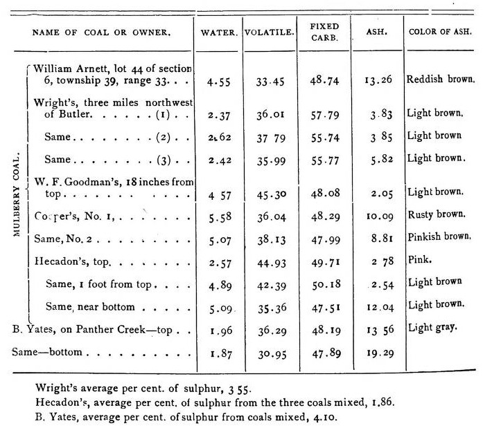 Stone, for all ordinary purposes, can be obtained in most neighborhoods, but superior building rock is not of general occurrence. A good sandstone quarry was noted on the prairie three miles west of Rockville, and the sandstone immediately around Rockville affords a tolerably good building material. Good quarries of sandstone may be opened just south of Possum Creek. The best exposure of this sandstone is on Mound Branch, east of Butler. The rock of this quarry will favorably compare with the Warrensburg sandstone, of which it is probably the equivalent. Thirty-five feet total thickness was here observed. On Possum Creek it is about eighty feet thick. Limestones, suitable for making ordinary lime, can be obtained in easy distance of most neighborhoods. Good beds of fire clay can be found beneath most of the coal seams. Gypsum or Selenite seems generally to abound in the under clays of the lower coal beds. At several places in townships 38 and 39, range 31, are large masses of cellular brown Hematite of light specific gravity. Excavations may prove these beds to be thick and valuable enough to work, provided they are not too silicious. On the slopes of Sand Mound, at the county line, and also north of Rockville are similar exposures of ore, but it is often too silicious. West of Rockville, in bank of Panther Creek, are broken and lenticular strata of carbonate of iron of sufficient thickness to claim attention. In Bates, as in Vernon, are found wells of disagreeably tasted water. Mr. Newberry, in. section 22, township 40, range 29, has a well eighteen feet deep, of very cool water, but alas, to the parched man it brings poor relief. It has a strong epsom salts taste. It acts somewhat on the bowels, does not cook well and will not wash. The lower eight feet of this well is said to be in black shales. Two miles east, John Young, has a well with water having a pleasant sulphur taste. At Wilcox's, west of Crescent Hill, is a well over eighty feet deep, which was reported to be saline, but I could not discover it, which fact might have been owing to the abundant rains just previously fallen. About fifty-seven feet of water generally stands in it. The water is said to wash well, but gives the clothing a yellow color unless rinsed in other water. At Parkersville some mineral tar colors the sandstone and small quantities drip from the crevices. Near Mr. Holderman's a well was. bored over 500 feet for oil, but obtained none. Another small tar spring, flowing from sandstone, is in section 23, township 40, range 33. The flow is weak, and on stirring the water a beautiful iridescence is seen on the surface, formed of plays of green and red, beautifully arranged. On Mulberry Creek, west and northwest of this, the limestones indicate the presence of bitumen by their odor. Four miles south of Butler small drops of tar are seen upon fracturing the limestone. In this instance the tar occupies cavities formerly tenanted by fossils. At Braggin's, east of Butler, is a soft sandstone, impregnated with oil. A chaleybeate spring also issues from the same sandstone. At H. B. Francis', in the southeast section 4, township 40, range 33, is a weak flowing but strongly impregnated alum spring. It issues from shales just below limestone No. 67. On the land of Moses Martin, in southeast section 18, township 40, range 32, is a salt and sulphur well. The well is 117 feet deep from the surface of the high prairie. Epsom salt water occurs near the upper part. That towards the bottom tastes of sulphuretted hydrogen. Mr. Martin says that the formations passed through were chiefly sandstone with a four foot limestone bed at twenty-two feet and at thirty-two feet coal and slate. Then below were soapstone and sandstone, containing bitumen in the lower part. When first bored the well was left dry. Returning several days after there was found to be sixty feet of water in the well. At sixty feet depth a cavity containing gas was entered and an explosive report was heard fifty yards off. Even now if the water falls below sixty feet reports are sometimes heard. The water is said to to be soft and better for washing than rain water. Some parts of the county are well watered, in the others the supplies of water are weak. There is a good spring of water at Butler, and water of good quality is easily obtained in wells. On a ridge, in township 38, range 32, good water is obtained at easy depth. At New Home there is a large spring of excellent water which never fails. There are other good and never failing springs in south part of township 39, range 32. One very pretty spring was observed on Mr. Ward's land, in section 35, flowing from limestone high up in the hills. In a deep shaded glen, on Richard Eleven's land, in south section 21, township 39, range 30, a very pretty and full flowing spring was noted. Around the base of the hill at the head of Peter's Creek, are wet places, indicating the existence of concealed springs. Springs may generally be found on the sides of the high mounds. One very excellent one is on the mound in section 9, township 41, range 33. In portions of Bates County are large bodies of excellent land, and there is also some thin soil in the county. About the thinnest soil is that north of Butler, including the north part of township 40, part of township 41, and part of township 42, range 31. The soil on the plains around the head of Miami Fork in township 41, range 32, is quite thin. Where wood-land occurs on the hill-tops the soil is more often poor; for example, the country south of Possum Creek, slopes to Mound Branch and head of Panther Creek. Most other portions of the county include tracts of rich soil. The best lands will produce yearly sixty bushels of corn per acre, other lands thirty-five to forty-five bushels. Good wheat crops are also generally raised. The natural prairie grazing is good and there are still large tracts of immense prairie land open for common grazing. Blue grass has begun to take well. There are but few bearing orchards in the county but we see no reason why fruit may not be successfully produced. Although Bates is a prairie country we find extensive bodies of good timber along the larger streams, especially on Grand River, Mormon Fork, the Marais des Cygnes and Miami and Mulberry Creeks, with good bodies near head of Panther Creek, a good deal of timber along Mound Branch and Walnut Creek. Among the best varieties are hickory, oak, elm, honey locust, ash, linden and sycamore. I saw no white oak trees. A few may probably be found near the head of Panther Creek. Pecan occurs on the Marais des Cygnes. |
||
Bates County Missouri MOGenWeb |
||